One Of Arizona's Most Extraordinary Adventures Is A Unique Road Trip Through Time Near Phoenix
Countless experiences await in Arizona, from desert treks leading to stunning waterfalls to rafting down the Colorado River through the incredible Grand Canyon National Park. You don't even have to leave your car to enjoy adventures in Arizona, as the state boasts some of the most scenic road trips in the US. One of these — Arizona State Route 88, otherwise known as the Apache Trail — begins only 36 miles east of Phoenix, and can be done as a day trip from anywhere in the Phoenix metropolitan area.
Arizona's first historic highway has a fascinating history. For more than 1,000 years, the Salado, the Apache, the Yavapai, and other Native American tribes used it for migrating between winter homes in the Sonoran Desert and summer homes in the mountains. In the early-1900s,white settlers converted the trail into a road for transporting supplies to the Theodore Roosevelt Dam construction project on the Upper Salt River. The 357-feet-tall dam was the the highest masonry dam in the world at the time, and was named after then President Theodore Roosevelt.
Around the same time, the Southern Pacific Railway began conducting tours along the route, branding it as the "Apache Trail" to draw more tourists. Catchy moniker aside, the route's scenery was so gorgeous that even President Roosevelt himself became a big fan: "The Apache Trail combines the grandeur of the Alps, the glory of the Rockies, the magnificence of the Grand Canyon and then adds an indefinable something that none of the others have, to me, it is most awe-inspiring and most sublimely beautiful."
Embarking on the Apache Trail
Starting from the town of Apache Junction, AZ-88 (the Apache Trail) winds northeast for around 45 miles before connecting to US-60 near Miami, AZ. From here, heading west on US-60 back to Apache Junction forms a 120-mile loop that can be done in a few hours to a full day, depending on the number of stops. And there are plenty of interesting ones along the way.
Several worthwhile stops are clustered at the beginning, the first being the Superstition Mountain Lost Dutchman Museum. Here, you can learn more about the history of this part of Arizona, including the lives of Native American people and early western settlers, the area's mining and film industry, and fascinating local legends. One mile beyond the museum is another must-see for history buffs, the Goldfield GhostTown, where you can enjoy a taste of the Wild West and many unique family-friendly activities.
Outdoor lovers should check out the Lost Dutchman State Park, located a mile past the museum at the foot of the striking Superstition Mountains. This is a popular but dangerous hiking area where an unusually high number of hikers go missing every year. We highly recommend exploring some of the gorgeous trails in this state park, but exercise caution to avoid becoming the next statistic. Start your hike early in the morning or late in the afternoon to keep out of the midday heat, bring plenty of water, and don't stray off the trail.
Stunning desert scenery, another historic town, beautiful lakes, and more
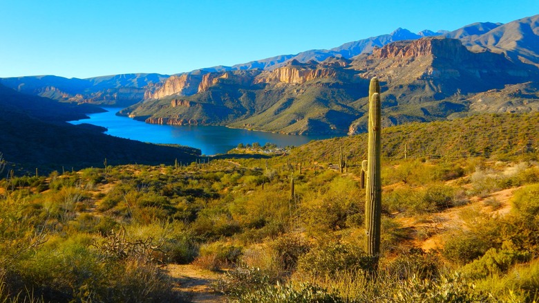
After the Lost Dutchman State Park, the Apache Trail enters a rugged, rolling wilderness studded with cacti, shrubs, and small trees. For the next 9 miles the desert vistas are long and wide before suddenly opening up to Canyon Lake — the first of three reservoir lakes along this portion of the upper Salt River. Fishing, boating, and waterskiing are all popular activities on this mesmerizing lake, which has an ample supply of pontoon boats, canoes, kayaks and other watersports equipment available to rent at the Canyon Lake Marina.Another option is to do a sightseeing or dinner cruise on the iconic Dolly Steamboat.
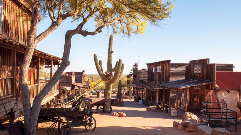
Three miles past Canyon Lake is Tortilla Flat, a historic Old West town nestled in the Superstition Mountains. These days, a handful of wooden buildings are all that remain of what was once a bustling stagecoach town. But the Superstition Saloon, with its quirky western decor and "Killer Chili" is a truly unique treat. Past Tortilla Flat, the Apache Trail becomes unpaved with steep switchbacks and is not recommended for RVs and other large vehicles. For those who continue the journey, more stunning scenery, two more lakes, and an impressive dam and bridge lie ahead.
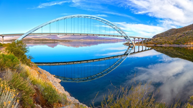
Apache Lake is similar to Canyon Lake in terms of its recreational activities, but less crowded and more serene due to its more remote location. Roosevelt Lake, the last one, is the largest of the three lakes, at 22-miles-long with 128 miles of shoreline. As you're approaching, there's a turn off to the Theodore Roosevelt Dam Overlook, where you can gaze in awe at the massive historic structure. Beyond that another .7 miles is the Inspiration Point Interpretive Overlook, where you can see the Roosevelt Lake Bridge. This bridge spans the lake and is the longest two-lane, single-span, steel-arch bridge in North America.