An Ingenious Online Planning Tool Could Easily Save Your Life During A Grand Canyon Hike
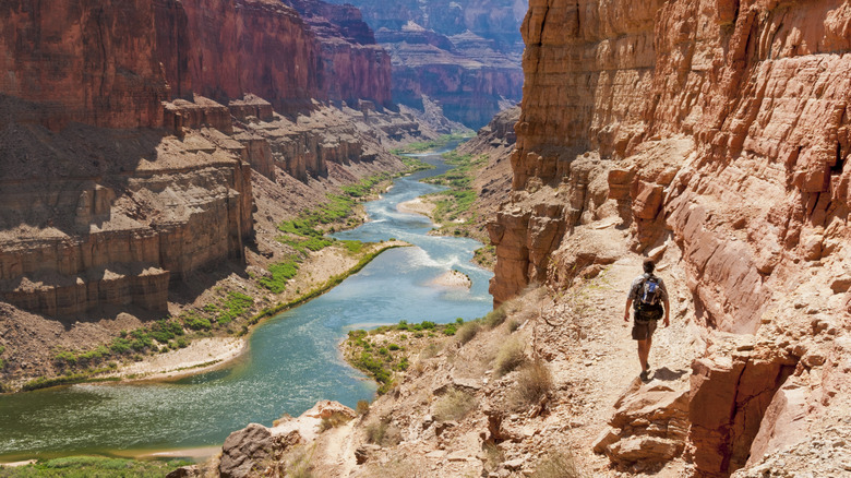
The Grand Canyon is a spectacular space, a land of never-ending vistas, colors, and oohs and aahs. But adventures here must be earned, and they don't come without some extreme risks. For example, the canyon's world-famous Bright Angel Trail is considered one of America's most dangerous hikes due to its steepness, lack of shade, and exposure to the elements, especially the intense heat and sunlight of the harsh desert environment. This lethal combination of conditions puts hikers at risk for dehydration, heat exhaustion, and yes — even death.
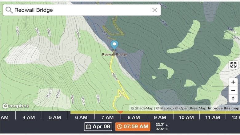
Fortunately, Bright Angel Outfitters has developed a potentially life-saving tool to help hikers better plan expeditions and avoid the sun when it's at its brightest and hottest. The Grand Canyon Shade Tracker is an interactive online map that allows users to enter the date and time of their hike plus a trail, campground, or other landmark to see whether that point is sunny or shaded at that particular point in time. You can also zoom in or out for an enhanced perspective and scroll along a time continuum to see how the sun—shade pattern morphs throughout the day. This brilliant tool is easy to use, totally free, and may be super useful when planning an extended trek, like the difficult 24-mile rim-to-rim adventure that is not for amateurs.
Other nifty online tools Grand Canyon hikers should know about
A few other online tools can make planning (and executing) Grand Canyon hikes easy-peasy. The National Park Service Mobile App allows users to access information on 400 national park sites throughout the U.S., including Grand Canyon National Park. The information includes interactive maps plus detailed information on the park, like amenities, accessibility, things to do, and tours as well as news, alerts, and special events. Best of all, you can download the app's map of Grand Canyon onto your phone and access it even when you're offline. This means that even deep in the belly of the canyon, when you'll likely be without cell service, you can still see your location on the app's map to help with navigation.
Yet another helpful electronic tool can be accessed right at the Grand Canyon trailheads themselves along with a few other strategic park locations. These are QR codes that you can scan with the camera on your mobile phone, which takes you to a regularly updated park web page with information on current trail and weather conditions, water locations, and general safety tips. But don't rely solely on this and the other electronic tools described in this article for safety information while you're in the park, since you may not have cell service and/or your phone may lose its charge while you're hiking. Do your research ahead of time about the challenging hiking conditions in the Grand Canyon, especially how to stay hydrated on long, strenuous hikes.