The Best Road Trip Routes In America For Unforgettable Fall Foliage Views, According To Research
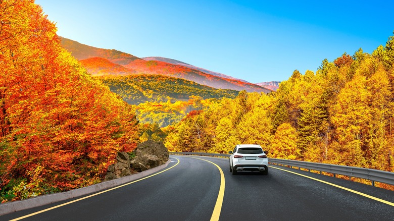
The great American countryside is a wonderful and sprawling place. There's something truly magical about getting in the car and just driving along a majestic route to take in the scenery. From coastal highways to mountain passes that provide the lifeblood of connection to distant communities, the entire nation is spoiled for choice when it comes to beautiful, scenic drives. These are made even more iconic during the annual shift in the color palate and temperature that sends beauty into overdrive come autumn time. The fall foliage is truly iconic in places like New England, but there's a bevy of phenomenally pretty scenery to melt over throughout the country.
No matter where you call home, there's actually quite a bit of choice available just beyond your front door. Similarly, roadtrippers might consider stringing together a lengthy adventure to capture the magic of one or more scenic drives a little farther afield. There's certainly something to be said for the rural highways that meander their way through western Massachusetts, Vermont, or upstate New York, but the Midwest, Pacific Coast, and beyond all hold magical treasures rivaling these classic fall drive destinations. To create this autumn road trip route recommendations, we consulted local and state resources and tapped into our foliage-hunting experiences. Come explore the best routes for a fall road trip with friends or family, and you might discover a path or two that veer their way through your neck of the woods!
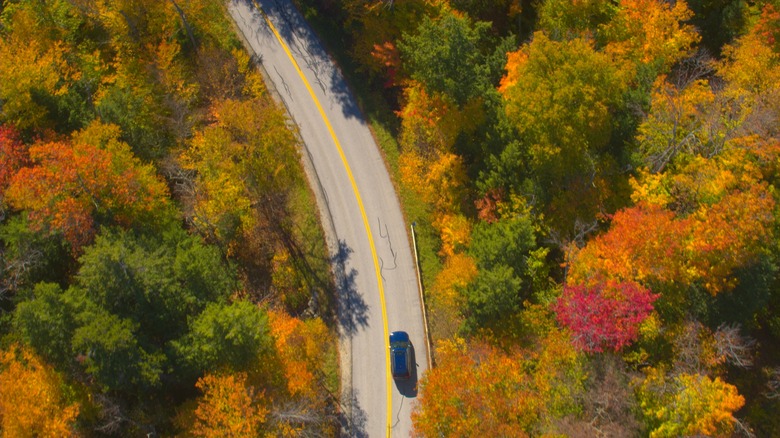
The Finger Lakes region, upstate New York
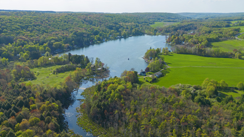
Sitting between Buffalo and Syracuse in upstate New York, the Finger Lakes region is a truly awe-inspiring landscape that features 11 elongated water bodies stretching primarily in a north-south orientation. True gems like Seneca Falls — a historic town that hosted America's first Women's Rights Convention — and Ithaca (one of the East Coast's most picturesque towns) are nestled within this little slice of New York autumnal heaven. Indeed, the legends of the land's original Native American population stitch the lakes directly into evidence of the Great Spirit. The glacial lakes that claw their way down the northern landscape are left as a handprint that signals its blessing, according to the myth. The region as a whole is fairly sprawling, covering a 9,000 square mile swath of northern New York, but numerous lake drives can be achieved in under an hour (each direction) and gift you an unforgettable afternoon of wide-eyed goose necking out the window.
The drive along Route 89 (following Cayuga Lake north from Ithaca to Seneca Falls) is a particularly special trail. It's roughly 40 miles and takes about 50 minutes to complete — not accounting for any stopping for pictures or a few extra looks you might do along the way! On this road, be prepared to see wineries, campgrounds, nature preserves, centers, and parks. The Taughannock Falls State Park and overlook viewpoint alongside the Black Diamond Trail also sit along Highway 89's route. Drivers will consistently cross small streams that flow into the lake, adding to the electric atmosphere that fall color changes bring.
Eat and drink your way along California's Highway 1
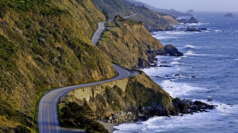
The California coast is a phenomenal place for a drive. It's perhaps far less prominent as a fall foliage option, however. With the blazing red and oranges of the east capturing so much of the collective attention of autumn lovers, it's easy to see why California might be underappreciated. Even so, the fall color changes are dramatic here, underpinned by the deep blue of the Pacific Ocean acting as a constant co-star and a mood-setting backdrop. The Pacific Coast Highway (Highway 1, stretching the coastal distance of nearly the entire state) is the second longest continuous route in the United States, but the slice of pavement that's of particular interest to fall color hunters is in the north of San Francisco.
This 150-mile expanse connecting Big Sur to the Bay Area is a glistening paradise filled with brilliant golden hues and ancient redwood forests. Throughout the drive, you'll come into contact with numerous little seaside towns that call to mind what historic road trips might have been like before the Interstate System made distance driving a chore rather than a delight. There are plenty of vineyards to see along the way, too, making for tremendous opportunities to stop for a day or an evening. The route brings drivers through Sonoma County, a wine-making community bristling with vineyards and other features that add immense depth to a visit beyond the glass (like a half dozen stops along the California Cheese Trail!).
Bask along the shore in Door County, Wisconsin, 'the Cape Cod of the Midwest'
Physically jutting out into Lake Michigan above the sheltered harbor of Green Bay and the coastal haven of Milwaukee, Door County isn't particularly large, and it might come across as unassuming to those not in the know. The peninsular landmass separates the Green Bay waterway from its larger neighbor, Lake Michigan, and it features numerous state parks and hidden maritime treasures along the two main thoroughfares (57 and 42) that snake their way up the coastal edges to Sister Bay before arriving together at Gills Rock and Northport. Note that on the map, these two roadways are the primary highway options for moving through the area.
The Door County Coastal National Scenic Byway is perhaps the most enlightening route when seeking fall foliage here. It's the Highway 42 route from Green Bay Bluffs northward through Ellison Bay and then on to Northport (clocking in at about 66 miles in total). The final 12-mile stretch is where the magic really comes alive, although nearly everything you'll encounter along the whole route is stunning. The rural vegetation reaches up to the sky in brilliant, fiery fashion in the autumn months, and the weather remains comfortable and firmly in a sweater-but-not bulky-coat territory (averaging around 50 degrees Fahrenheit). The roadway is dotted with beaches, coastal parks, lighthouses, and unique sightseeing draws like Wisconsin's largest house and a plethora of cider orchards.
Stand in awe at Glacier National Park and drive the Continental Divide in the Montana backcountry
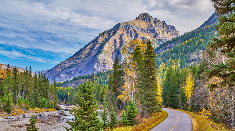
Glacier National Park is one of the country's most stunningly beautiful landscapes. The whole area is crisscrossed by hiking trails (over 700 miles worth), and the valley lakes are the product of glacial carving. Across America, it's essentially unarguable that the most vividly colorful, placid, and beautiful lakes are those formed by glacial movement millennia ago. The meadows, mountaintops, and trailheads of Glacier National Park are found in the high latitude, northwestern corner of Montana. It offers a visually immaculate greenspace to anyone making the journey. Indeed, Big Sky Country is simply indescribable to those who've never had the opportunity to explore its vast wilderness.
Fortunately, for drivers hoping to explore the park's foliage in comfort and style, the trails and open-air environment aren't the only things of beauty to be seen here. The Going-to-the-Sun Road is a 50-mile highway pass that traverses the continental divide — the Rocky Mountain division of North America's east and western waterways. These mountains were called "the backbone of the world" by those of the Blackfeet Nation generations ago, and gazing upon their jagged peaks today during a fall drive certainly brings up powerful feelings of a Goliath's geographic might. Driving along the road, you'll encounter plenty of stopping opportunities to gaze down upon the world, but Jackson Glacier Overlook is perhaps the best spot to let time stop, if for just a minute.
Cruise the Blue Ridge Parkway through North Carolina and Virginia
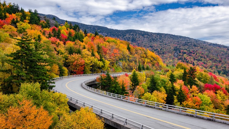
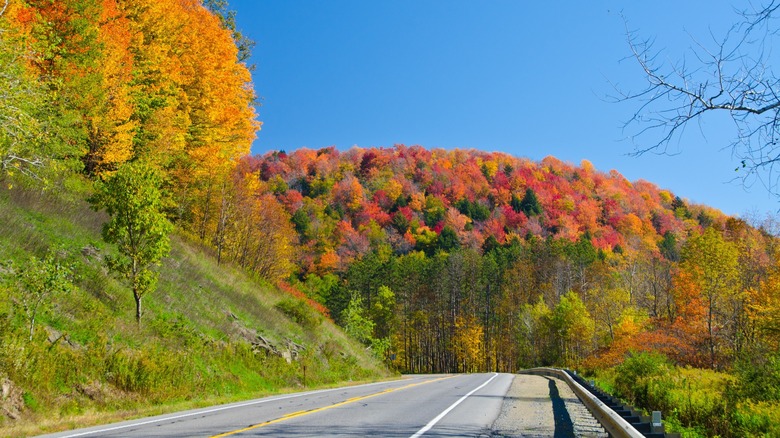
The Blue Ridge Parkway careens through Virginia and North Carolina over a span of 469 miles, and it shows off the lengthiest display of fall's fiery change anywhere in the region. This is perhaps due to the massively varied slope direction of the rolling mountaintops and the dramatic change in elevation throughout the drive. At any rate, September weather often rings in the shift that continues well into November. The trail starts south of Asheville (in Cherokee) and continues all the way up to Charlottesville in north-central Virginia. The Parkway connects Great Smoky Mountains National Park with Shenandoah National Park. It was constructed in 1935 and continued throughout the Roosevelt administration as part of the government's New Deal programming (as well as beyond it).
The entire length of the roadway is worth dilly-dallying along. Ambling up (or down) the Parkway brings you into close contact with sprawling hills and mountains along the Appalachian ridge. These vast elevation changes make for a spectacular sea of continuous tree lines that sit one behind the other as if waves on the ocean. During the fall months, they change in dramatic fashion to a fiery display of dazzling reds, oranges, and yellows, as to be expected. Perhaps the most exciting news of all is that the best time to explore the Parkway is highly dependent on your own schedule. In early October, the sights of Grandfather Mountain and Mount Mitchell reliably burst into flames while Chimney Rock waits to ignite until November.
Take in fiery color along Alaska's Seward Highway en route to Kenai Fjords National Park
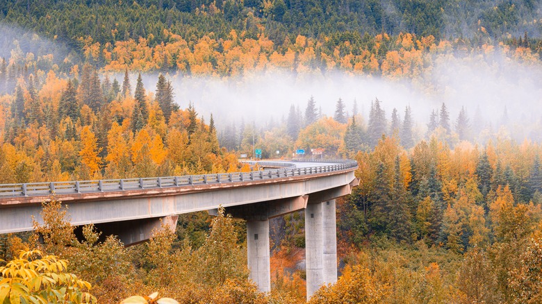
Alaska might seem like a place not worth visiting in the fall. As a distant, northern extremity of the United States, it can seem cold, icy, and devoid of the teeming life that fall color changes evoke in the mind's eye. Even though most people might overlook The Last Frontier, its residents and visitors enjoy some truly spectacular fall changes that many will never see. The Seward Highway connects Anchorage to Seward and runs 127 miles from end to end. Along the way, you'll be treated to a blast of fall color throughout the ragged terrain.
Drivers are also brought into the orbit of Kenai Fjords National Park. It's one of the most photogenic destinations in the United States and provides a uniquely contrasting color palette to the typical auburn glow of autumn. Deep blues dominate the visual spectrum, and with 60% of the park's total landscape covered in snow and ice, it's perhaps a uniquely welcome, if not dramatic, change of pace.
Wind your way through New England's iconic fall colors
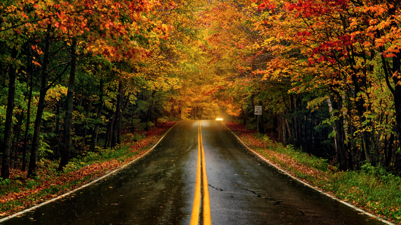
No list of fall delights would be complete without mentioning New England. The iconic backdrop for a fall foliage adventure, New England's winding roadways, blanketed tree lines, and sloping hilly geography make for the perfect excursion in an autumn wonderland. Places like Walden Pond in Concord, Massachusetts (one of New England's most charming places to stay in the fall), New Hampshire's Crawford Notch, and The Kancamagus Highway (a portion of New Hampshire Route 112, stretching along a 34.5-mile long treasure trove of fall color) are typical destinations for foliage hunters. Granby Road in northeastern Vermont is another classic option for rural driving along a brilliant display of color.
New England is the preeminent destination in many people's psyche. The northeastern region's landscape lends itself perfectly to this designation, and generations of transcendentalists who called it home helped shape a national recognition that has stuck to the region's reputation. Visiting New England is a great opportunity to explore classic American heritage sites, too. Concord is home to some of the first actions of the Revolutionary War. Similarly, Hubbardton Battlefield in Vermont is the state's only Revolutionary War battle site, but it lays claim as a major success for the fledgling American forces.
Drive through covered bridges in central Michigan
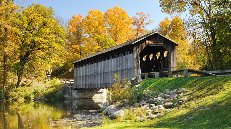
Michigan's covered bridges are more than just crossing points to navigate the state's waterways. These are a glimpse into a time that came before. Many covered bridges in the state were built over a century ago and remain in use to this day. They're a picturesque and truly iconic remnant of a simpler time and feature prominently in any rural driving you might do in Michigan. Fortunately, a lengthy road trip route circles its way through Michigan to see a range of scenic, rural bridges peeking through time immemorial. These enable modern drivers to traverse the same ancient streams and rivers that people in antiquity sought to cross.
The drive winds through Michigan to cover over 600 miles of roadway, so it's not for the faint of heart! It demands around 10½ hours, but the segment between Fallasburg Covered Bridge and Traverse City takes just under 2½ hours to complete (a 150-mile journey). The latter brings drivers along the edge of Manistee National Forest, a sprawling greenspace along Michigan's western coast. This area is also a product of the Depression Era's regenerative efforts to put out-of-work Americans back into employment while restoring logged lands to their former glory. Regardless of the long or short route you select, there's plenty of blazing foliage to take in. Stops in towns like Frankenmuth make for an interesting addition, too. The northeastern community is revered for its use of Bavarian stylings throughout its architecture and covered bridges.
For historic drive lovers: Pennsylvania's iconic Route 6
Route 6 is a historic roadway that cuts a long trail across the United States. Starting in Provincetown, Massachusetts, and continuing on until it reaches Long Beach in southern California, the sprawling highway weaves its way in and out of Cleveland, the Chicago suburbs, Des Moines, Omaha, and Denver. In Pennsylvania, however, drivers will find a veritable cornucopia of color when taking to the historic highway in the fall months. No matter which part of Pennsylvania's stretch of Route 6 you decide to tackle, you're in for a visual treat. Having said that, there's something unique about the Pocono Mountain region of the roadway. Lake Wallenpaupack (one of the East Coast's best swimming lakes) nestles north of Scranton, PA, and adds to the majesty of the region's brilliant blaze of fall colors.
Route 6 brings you along a winding journey across eastern Pennsylvania. Along the way, you'll see small-town America brought fully to life in places like Milford and Honesdale. Grey Towers is also found here — a National Historic Landmark that was once the home of Gifford Pinchot, the U.S. Forest Service's first chief and Pennsylvania Governor. The slowly winding path of the highway, combined with all the classic sights and sounds of the region's mountainous terrain, make for the perfect autumn getaway for anyone seeking to bathe themselves in the changing foliage.
Find inspiration throughout Maine's Acadia National Park loop
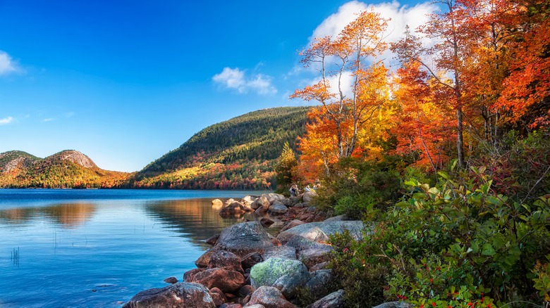
A true treasure of the northeast, Acadia National Park is found sprawled across Maine's Mount Desert Island. Roughly three hours by car from Portland, ME, to the south, Mount Desert Island isn't the most centrally located spot in the country by any stretch. Even so, a trip to explore Acadia National Park — a gem that takes up 45,000 acres of landscape on the craggy Atlantic coast island — is always met with an out-of-this-world experience. It's the American coastland that experiences the first glimpse of morning rays, making for a brilliant and unique light show for early risers. Moreover, the national park is on many a bucket list for East Coast travelers and enthusiasts due to its abundant hiking trails (around 150 miles in total), beaches, and coastal towns.
The highlight of a fall journey through Maine's coastal treasure has to be the carriage roads, however. They are vehicle-free and weave through 45 miles of mountain, lake, and forest landscape. Getting out of the car and taking a carriage ride instead is a great change of pace for those looking to slow down and take in the calming sights and sounds of an autumn day. The roads were the gift of John D. Rockefeller Jr. and his family and were established to preserve the natural beauty of the island and its rustic habitat. Today, explorers seeking a view of the changing fall colors can bask in their radiant glow in the open air.
Explore Washington state's outrageously beautiful Olympic Peninsula
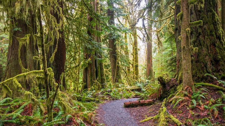
Olympic National Forest sits in the center of a coastal jut breaking ever so slightly away from Seattle on the other side of Puget Sound. Wonderful beaches feature on the coastline, but these destinations have nothing on the drive itself that explorers can take in around Highway 101 as it rings the peninsula. The full drive commands an eight-hour commitment, but there's so much to see and do here that multiple stops along the way could easily stretch a voyage through this Pacific Northwest gem into a multi-day adventure.
The national park covers over 1 million acres of forested, rolling landscape, and the views you'll experience here are simply remarkable. There's nothing quite like driving along a ridge or standing on a hilly peak and looking out over the endlessness of serene forestland. Hoh Rain Forest is a standout here, too, with ancient lichens interacting with towering Sitka spruce and hemlock that silently inch ever closer to the sky.
Driving counterclockwise around Highway 101, you'll experience glacial lakes, Native American reservations, and plenty of viewpoints overlooking waterfalls, waterbodies, mountains, and primeval forests. Throughout the drive in crisp autumn air, you'll find plenty of opportunities to stop the car and get out for a hike, as well as break up the journey and allow each new highlight to stand on its own.
Methodology
The driving routes highlighted here were collected from our leaf-peeping expeditions. We also consulted information provided through state and local tourist guides and federal resources, such as the National Park Service. Other sites, like Outside Online, provided context for elements like hiking trails and other beautiful features of the natural environment. These routes span much of the country, showcasing the diversity of fall foliage and the wonderful outdoor experiences autumn color hunters can enjoy.